
Tracing a Williamson County Street
A Williamson County street directory should begin with a situs address, then follow the location through county systems. The situs is the parcel's physical location. It is not automatically the same as an owner's mailing location, and neither record establishes every person who may be present there. Preserve the street number, directional prefix or suffix, city label, and ZIP before opening another index. Those small details prevent a false parcel match.
- Run the address in the Property Assessor search and save the owner, parcel description, lot, and sale clues returned.
- Locate the same parcel in the county mapping viewer and compare neighboring polygon boundaries.
- Use GoVoteTN only for an individual voter-name or address search, not as a street-wide list.
- Search the Register's deed route with the owner, legal description, lot, or subdivision to establish a title chain.
- For an earlier address question, ask library staff whether an appropriate historical directory or address-arranged volume exists.
Each step produces a different kind of evidence. Keep the parcel number and legal description with the search notes so a later deed or map result can be checked against the same land.
Williamson County Street Directory Fields
The Assessor form is a practical street-directory starting point because it accepts both a property address and a number of land identifiers. It exposes optional Owner Name, Property Address, Subdivision, City, Lot Number, Map, Parcel, and last-sold date fields. Its visible list uses Owner(s), Property Address, City, Parcel Description, Lot Number, Sale Date, and Price. The form does not expose a ZIP field, an all-addresses-on-one-street command, or a documented whole-street export.
| Assessor field | Street-directory use | Search caution |
|---|---|---|
| Property Address | Start with the county situs | Try directional and abbreviation variants |
| Owner Name | Cross-check a recorded owner | Use last-first and initials when needed |
| Subdivision / Lot | Bridge a street to the legal record | May be essential for changed addresses |
| Map / Parcel | Anchor the same land in GIS and deeds | Do not treat format as published if it is not shown |
| Sale dates | Narrow a transaction period | A transfer is not necessarily a move date |
The public Assessor screen shows the search form used for this part of the Williamson County street directory.
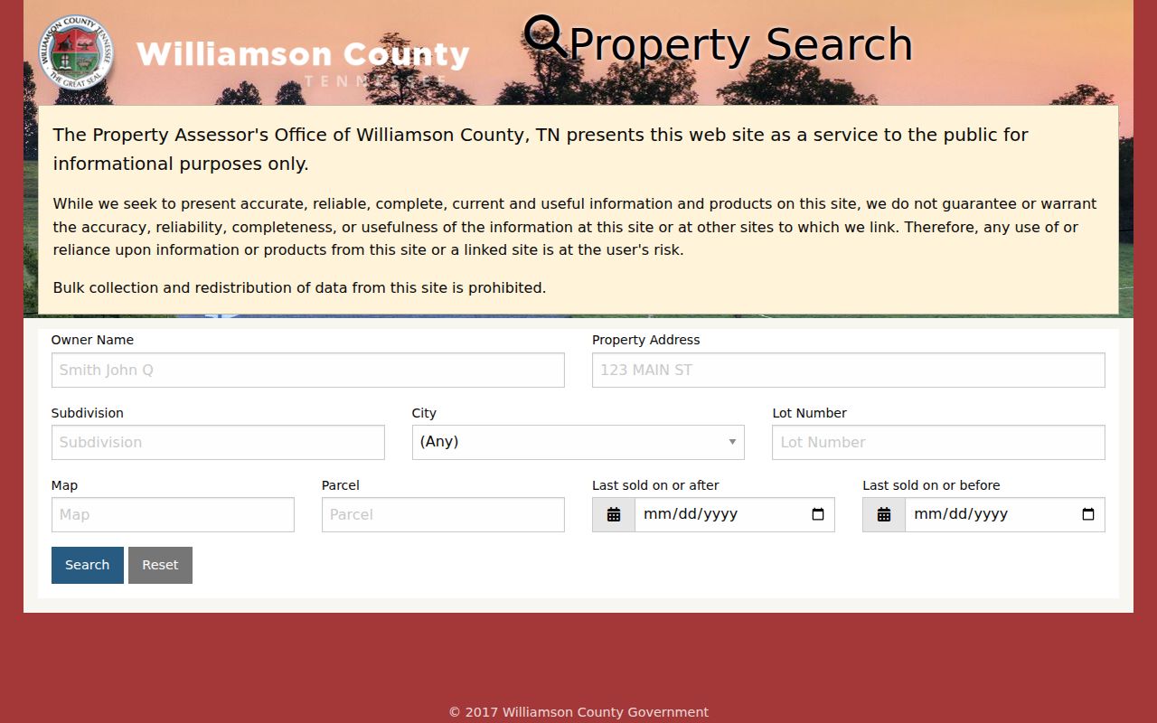
The form supports a focused parcel search, not a promise of a complete street roster. Search progressively and verify each parcel with the map.
Williamson County Parcel Map Clues
The county map hub links Internet Mapping alongside civil district, voting district, ZIP, zoning, flood, and other map resources. The public ArcGIS shell is JavaScript-heavy, so its exposed button labels and export controls were not verified. Its official REST layer does provide useful parcel metadata: ADDRESS, streetnumber, streetname, parcel_id, owner1, owner2, own_street, own_city, own_state, own_zip, deed_book, transfer-date fields, SUBDIVISION, and CITY.
For a short street segment, zoom to the target, select its polygon, and note the parcel identifier and subdivision. Then inspect touching or facing parcels in the same map window. The REST service supports query formats and has a documented maximum record count of 1,000. Corporate limits, communities, voting locations, zoning, and flood layers explain geography. They do not identify a household.
Note: Map fields can change by service version, so save the date inspected with any address evidence.
Williamson County Situs and Mailing Addresses
Four keys often appear in a street search: the map polygon, the assessor situs, the owner's mailing address, and the deed's legal description. The GIS metadata keeps situs and owner-mailing attributes separate. A situs tells where the parcel is. A mailing field tells where tax correspondence is directed when it is visible. It does not prove a personal residence. A recorded deed may use a lot, block, subdivision, or metes-and-bounds description without the postal address.
- Parcel
- A unit of land shown on the county map and tied to identifiers used by the Assessor.
- Situs address
- The physical street address attached to a parcel for county property work.
- Plat
- A map of lots, streets, easements, or dimensions that can connect an address to a subdivision.
- Criss-cross directory
- An address-arranged historical directory, if the library holds a volume for the needed year.
This distinction is the main safeguard against turning an ownership clue into an unsupported claim about residents along a street.
Williamson County Deeds by Street
Move from a confirmed parcel to the deed chain by using the current owner, lot, subdivision, legal description, or book reference. The practical sequence is parcel, current owner, purchase deed, seller or grantor, then the seller's earlier acquisition as grantee. The Register's TitleSearcher coverage lists online deed index and images from January 1, 1981 forward, old index books for 1951 through 1980, and non-indexed images in Books A1 through 379.
That cutoff is a local street-search quirk. If the online title path stops, compare the same legal description with the old books, Register route, or Archives index rather than assuming the property has no earlier record. A TitleSearcher cross-reference or refer-back can connect related instruments. “Not Indexed” means an instrument has not been verified or certified, so read the source carefully.
For a backward address history, use the Past Residents page rather than treating the street directory as a full title report.
Williamson County Street Records Compared
Address-keyed sources overlap, but their outputs are not interchangeable. The Assessor and GIS establish the parcel. The Register establishes recorded title history. GoVoteTN can return an individual registration match. Permits and code records may document a project or case when a custodian releases the file. Historical sources can establish an earlier address connection. Use the record set that matches the exact question.
| Street source | Address key | What it can show | Access |
|---|---|---|---|
| Assessor search | Address, parcel, lot, subdivision | Owner, city, parcel description, sale clues | Free informational portal |
| GIS parcel layer | Polygon and street fields | Parcel, owner metadata, deed-book lead, map context | Free viewer and REST |
| Register index | Legal description, party, lot or book | Grantor, grantee, instrument, chain reference | 1981 forward online; older routes remain |
| GoVoteTN | Registered name or address | Individual registration and election information | Free lookup, not a block list |
| Permit or code file | Project site | Project, applicant, or case detail when public | City or county custodian request |
The Archives index and library sources supply the historical layer when the street directory moves beyond current parcel information.
Williamson County Permit Address Evidence
Address evidence also appears in project files. Franklin Building and Neighborhood Services connects building permits with Neighborhood Resources and code enforcement. Its public material describes enforcement work but did not expose a person or address case index. Williamson County Building Codes has Electronic Plan Review at its official route, but public search fields, a cutoff year, and owner display were not located in the inspected sources.
Use a permit as a dated project clue, not as a replacement for the parcel or deed record. Ask the relevant city or county custodian for an existing address-specific permit or code file. A narrow request can seek application, issue, inspection, project, or applicant material that is released. It should not ask the office to create a street-wide person list.
Franklin Municipal Court is another address-related route for city ordinance, code, traffic, parking, fire-code, building, business, and noise matters. Its reviewed page did not provide a public name-search portal. Give the clerk a citation or case detail when requesting a municipal record. For a county court matter, use the local clerk or the documented TNCIS route. Keep a case file distinct from a parcel result: both may carry an address, but they answer different questions.
Williamson County Voter Address Checks
GoVoteTN is useful after the address or name is already known. Its voter mode requires first and last name and allows an optional ZIP. Its address mode accepts street address, ZIP, city, and state. The public tool can return a registration match, polling place, districts, elected officials, and sample-ballot information when a match succeeds. It is not a whole-street mode. The research found no public control for returning every voter on a block or street segment.
Property owners who are not registered voters will not appear simply because they own a parcel. Tennessee voter records also exclude Social Security numbers, driver-license and Department of Safety identifiers, and protected documentation. The broader voter-file route has statutory conditions under T.C.A. §§2-2-112, 2-2-127, and 2-2-138, while the current Williamson County request form, fee, and delivery format were not verified. Use individual public matches only as one labeled clue in a street directory search.
For registration or address correction, contact the Williamson County Election Commission. Do not infer a result for a protected voter or a person who does not appear in the public lookup.
Williamson County ZIP Street Labels
Postal labels can complicate a street directory. The county ZIP map displays three separate Franklin ZIP codes, 37064, 37067, and 37069, while community and corporate-limit layers follow different geography. The Assessor form has no ZIP field. GoVoteTN uses ZIP as an optional name-search narrowing field and an address-mode field, but it does not return all addresses in a ZIP. USPS confirms delivery formatting, not residency.
A documented 2005 Postal Bulletin realignment moved 41 deliveries from College Grove 37046 to Arrington 37014 and 40 deliveries in the other direction. When an older record's ZIP differs from a current label, compare the parcel, lot, deed, map, and street spelling before deciding it is a different location.
Williamson County Historical Street Clues
Historical address work needs a source that matches the period. Williamson County Public Library Special Collections confirms city directories, local newspapers, yearbooks, court records, cemetery material, and microfilm, but its public pages do not publish a verified reverse-directory run. Contact staff before describing a particular year or address arrangement as available. Newspaper microfilm and the Archives can bridge a gap through notices, obituaries, deeds, probate, and tax references.
Franklin Sanborn maps are confirmed for 1888, 1893, and 1898. The January 1898 six-sheet Library of Congress scan can help compare building footprints, street layout, and block form. It does not name an occupant. Pair a map with a dated directory, deed, newspaper item, or archival reference before adding it to a Williamson County street directory trail.
Williamson County Street Directory Limits
A street record cannot show every person connected to an address. Property ownership and mailing fields do not establish occupancy. Public GoVoteTN lookup does not list all adults, children, or nonregistered people on a street. Utility customer lists and delivery data were not found as public county directories. Tennessee motor-vehicle information is restricted under the Driver's Privacy Protection Act, and the state's self-requested motor-vehicle record does not display an address.
Sealed, expunged, juvenile, adoption, and Safe at Home-protected information remains restricted. A historical record can also be stale or misindexed. Keep sensitive notes private and verify the original source with its custodian.